 Hagos S, Hailemariam D, WoldeHanna T, Lindtjørn B (2017) Spatial heterogeneity and risk factors for stunting among children under age five in Ethiopia: A Bayesian geo-statistical model. PLOS ONE 12(2): e0170785. doi: 10.1371/journal.pone.0170785
Background Understanding the spatial distribution of stunting and underlying factors operating at meso-scale is of paramount importance for intervention designing and implementations. Yet, little is known about the spatial distribution of stunting and some discrepancies are documented on the relative importance of reported risk factors. Therefore, the present study aims at exploring the spatial distribution of stunting at meso- (district) scale, and evaluates the effect of spatial dependency on the identification of risk factors and their relative contribution to the occurrence of stunting and severe stunting in a rural area of Ethiopia.
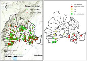
Methods A community based cross sectional study was conducted to measure the occurrence of stunting and severe stunting among children aged 0–59 months. Additionally, we collected relevant information on anthropometric measures, dietary habits, parent and child-related demographic and socio-economic status. Latitude and longitude of surveyed households were also recorded. Local Anselin Moran’s I was calculated to investigate the spatial variation of stunting prevalence and identify potential local pockets (hotspots) of high prevalence. Finally, we employed a Bayesian geo-statistical model, which accounted for spatial dependency structure in the data, to identify potential risk factors for stunting in the study area.
Results Overall, the prevalence of stunting and severe stunting in the district was 43.7% [95%CI: 40.9, 46.4] and 21.3% [95%CI: 19.5, 23.3] respectively. We identified statistically significant clusters of high prevalence of stunting (hotspots) in the eastern part of the district and clusters of low prevalence (cold spots) in the western. We found out that the inclusion of spatial structure of the data into the Bayesian model has shown to improve the fit for stunting model. The Bayesian geo-statistical model indicated that the risk of stunting increased as the child’s age increased (OR 4.74; 95% Bayesian credible interval [BCI]:3.35–6.58) and among boys (OR 1.28; 95%BCI; 1.12–1.45). However, maternal education and household food security were found to be protective against stunting and severe stunting.
Conclusion Stunting prevalence may vary across space at different scale. For this, it’s important that nutrition studies and, more importantly, control interventions take into account this spatial heterogeneity in the distribution of nutritional deficits and their underlying associated factors. The findings of this study also indicated that interventions integrating household food insecurity in nutrition programs in the district might help to avert the burden of stunting.